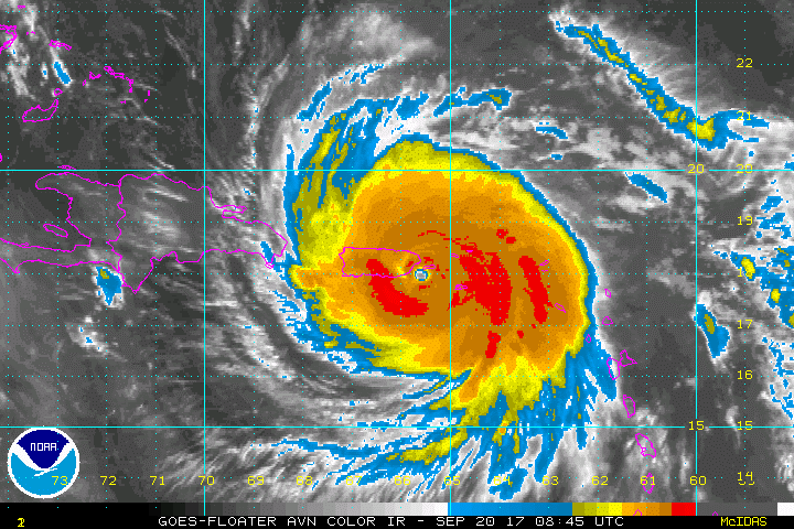
Hurricane Maria image from NOAA
On the early morning of September 20, 2017, Hurricane Maria made landfall in southeast Puerto Rico as a strong Category 4 storm with maximum sustained winds of ~250 kph. The powerful storm traveled the island in a northwesterly direction causing widespread destruction. This study focused on a rapid assessment of Hurricane Maria’s impact to Puerto Rico’s forests. Calibrated and corrected Landsat 8 image composites for the entire island were generated using Google Earth Engine for a comparable pre-Maria and post-Maria time period that accounted for phenology. Spectral mixture analysis (SMA) using image-derived endmembers was carried out on both composites to calculate the change in the non-photosynthetic vegetation (ΔNPV) spectral response, a metric that quantifies the increased fraction of exposed wood and surface litter associated with tree mortality and crown damage from the storm. Hurricane simulations were also conducted using the Weather Research and Forecasting (WRF) regional climate model to estimate wind speeds associated with forest disturbance. Dramatic changes in forest structure across the entire island were evident from pre- and post-Maria composited Landsat 8 images. A ΔNPV map for only the forested pixels illustrated significant spatial variability in disturbance, with emergent patterns associated with factors such as slope, aspect and elevation. An initial order-of-magnitude impact estimate based on previous work indicated that Hurricane Maria may have caused mortality and severe damage to 23-31 million trees. Additional field work and image analyses are required to further detail the impact of Hurricane Maria to Puerto Rico forests.
Other resources