• Skip to main content

NGEE–Tropics

Next-Generation Ecosystem Experiments

  • About
    • Our Project
    • Our Team & Affiliates
    • Our Partners & Collaborators
    • Phase 2 Proposal
    • Opportunities
    • Contact Us
    • NGEE-Tropics Twitter
  • Research
    • Research Overview
    • Modeling
    • Data
    • Field
    • Focus Area 1
    • Focus Area 2
    • Focus Area 3
  • Model
    • Modeling Overview
    • FATES Model Release
  • Data
    • Data Overview
    • Data Policy
    • NGEE-Tropics Data
    • ESS-DIVE Data Archive for NGEE-Tropics
    • Metadata Requirements
  • Publications
    • Publications List
    • Submit your Pubs & Highlights
    • Acknowledgment
  • Safety
    • Code of Conduct
    • NGEE-Tropics Safety
  • Resources
    • News
    • Hurricane Maria Imagery
    • Team Portal (internal)
    • Events
    • Documents, Reports, Presentations
    • Logos
    • Policies
      • Acknowledgment Policy
      • Authorship Policy (coming soon)
      • Data Policy
      • Software Policy
    • NGEE-Tropics Annual Meeting 2022
    • NGEE-Tropics at AGU 2022
    • NGEE-Tropics at AGU 2021
    • NGEE-Tropics at AGU 2020

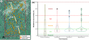
(left) Windthrown forest located near Manaus, Central Amazon, Brazil, and inventory and virtual plots used to quantify tree mortality. (Right) Distribution of windthrow tree mortality (%) from field subplots and satellite data with varying spatial resolution.
(left) Windthrown forest located near Manaus, Central Amazon, Brazil, and inventory and
virtual plots used to quantify tree mortality. (Right) Distribution of windthrow tree mortality (%) from field subplots and satellite data with varying spatial resolution.

  • (left) Windthrown forest located near Manaus, Central Amazon, Brazil, and inventory and virtual plots used to quantify tree mortality. (Right) Distribution of windthrow tree mortality (%) from field subplots and satellite data with varying spatial resolution.

    © 2025 NGEE-Tropics

    WordPress Design & Development by HyperArts