Interplay of Turbulence Regimes, Deep Convection, and Tree Mortality in the Amazon Rainforest
The Science
Although satellites with high spatial resolution have become available in the last decade, they have not yet been employed for the quantification of windthrow tree-mortality. Here, we address how increasing the spatial resolution of satellites affects plot-to-landscape estimates of windthrow tree-mortality. We combined forest inventory data with Landsat 8 (30 m pixel), Sentinel 2 (10 m), and WorldView 2 (2 m) imagery over an old-growth forest in the Central Amazon that was disturbed by a single windthrow event in November 2015.
The Impact
Although the three satellites produced reliable and statistically similar estimates (from 26.5% to 30.3%, p < 0.001), Landsat 8 had the most accurate results and efficiently captured field-observed variations in windthrow tree-mortality across the entire gradient of disturbance (Sentinel 2 and WorldView 2 produced the second and third best results, respectively). As expected, mean-associated uncertainties decreased systematically with increasing spatial resolution (i.e., from Landsat 8 to Sentinel 2 and WorldView 2).
Summary
Remote sensing estimates of windthrow tree-mortality were produced from Spectral Mixture Analysis and evaluated with forest inventory data (i.e., ground true) by using Generalized Linear Models. Field measured windthrow tree-mortality (3 20mx125m transects and 30 10mx25m subplots) crossing the entire disturbance gradient was 26.9 ± 11.1% (mean ± 95% CI).
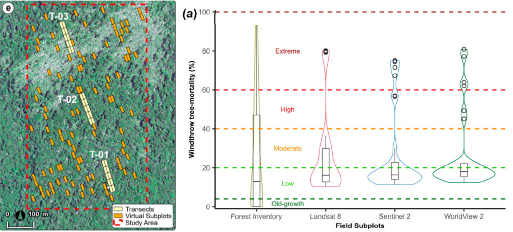
Figure. (left) Windthrown forest located near Manaus, Central Amazon, Brazil, and inventory and virtual plots used to quantify tree mortality. (Right) Distribution of windthrow tree mortality (%) from field subplots and satellite data with varying spatial resolution.
Contact: Daniel Marra, Max Planck (dmarra@bgc-jena.mpg.de)
Robinson Negron-Juarez, Lawrence Berkeley National Laboratory (robinson.inj@lbl.gov)
Funding
R.I.N.-J and J.Q.C. were supported by the Office of Science, Office of Biological and Environmental Research of the US Department of Energy, Agreement grant DE-AC02-05CH11231, Next Generation Ecosystem Experiments-Tropics (NGEE-Tropics). This research is part of the INVENTA (Interação Vento-Árvore na Amazônia), and the ATTO projects funded by the German Federal Ministry of Education and Research (BMBF contracts no. 01LB1001A and no. 01LK1602A), the Brazilian Ministry of Science, Technology, and Innovation (MCTI/FINEP contract no. 01.11.01248.00), and the Max Planck Society (MPG). L.E. was funded by the Amazonas State Research Support Foundation (FAPEAM) (PhDgrant no. 41640.UNI739.1607.28032019-65939) and supported by the Instituto Nacional de Ciência e Tecnologia (INCT)Madeiras da Amazônia.
Publication
Emmert L, Negron-Juarez R, Chambers J, Santos J, Lima A, Trumbore S, Marra D. Sensitivity of Optical Satellites to Estimate Windthrow Tree-Mortality in a Central Amazon Forest. Remote Sens. 2023, 15, 4027. https://doi.org/10.3390/rs15164027.