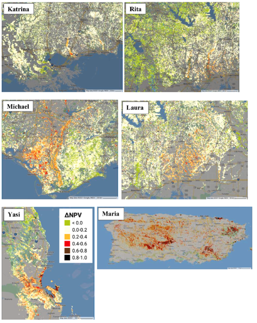
A team assessed how factors affect forest disturbance intensity across multiple regions and examined the difficulty to build a general cyclone impact model.
The Science
Cyclones have huge impact on our planet earth. After cyclone passed, some trees were fallen while some trees just lost some leaves. Why is that? Scientists use satellite images and study what factors contribute to the different impact on forests brought by hurricanes. Scientists found a 40 m/s wind speed threshold that affect the cyclones impact, but little consistency can be found on other variables among the studies of different cyclones. Each cyclone interacted with the landscape in a unique way. In addition, they discussed the difficulties to build a model which can predict where the next damage region would be due to upcoming cyclone.
The Impact
Climate change enhances cyclone-related rainfall, which worse the impact of cyclone on forests. Therefore, it is important to understand how the forested in different regions were affected by past cyclones and get better insights to prepare for future cyclones. This study reveals the links between remote sensing images derived forest disturbance intensity and the factors, including wind and rainfall, forest structure, terrain features, and soil properties at the landscape scale. The authors are the first to discuss the possibility to build a machine learning model to predict the impact of an unseen hurricane on forests.
Summary
This study addressed the importance of climate variables, terrain features, and forest properties in predicting tree damage caused by cyclones. Wind, elevation, and pre-disturbance vegetation condition are strong predictors. Machine learning technologies were used to build cyclone impact models. As machine learning models become more popular in earth science, this study showed that them still had limitations in cyclone effects prediction. The models worked well on hold out test data, but they had weak predictability on unseen cyclones. The authors believed that more finer scale data can be helpful to build local models work with similar ecosystems and landscapes, but the complexities of cyclone effects coupled with landscapes, soils, states of affected systems, climate change leads us to question the existence of an omnipotent cyclone impact model that works for the globe.

Contact (BER): Daniel Stover, SC-23.1 (Daniel.Stover@science.doe.gov)
Science Contact: Yanlei Feng, University of California, Berkeley (ylfeng@berkeley.edu)
Jeffrey Q. Chambers, Lawrence Berkeley National Laboratory, Climate and Ecosystem Sciences Division, Berkeley, CA, USA (jchambers@lbl.gov)
Funding
This research was supported as part of the Next Generation Ecosystem Experiments-Tropics (NGEE), funded by the U.S. Department of Energy, Office of Science, Office of Biological and Environmental Research under contract number DE-AC02-05CH11231.
Publications
Feng, Y., Negrón-Juárez, R., Chambers, J. Q. (2021) Multi-cyclone analysis and machine learning model implications of cyclone effects on forests, International Journal of Applied Earth Observation and Geoinformation, Volume 103, https://doi.org/10.1016/j.jag.2021.102528.
Related Links
Disturbance intensity map of hurricane disturbance. Katrina, Rita, Yasi, María have been validated with field observations and high-resolution airborne remote sensing images. UI Interface: https://ylfeng.users.earthengine.app/view/jagfengetal
Supplementary data to this article can be found online at https://doi. org/10.1016/j.jag.2021.102528.